Navizar Castle in Alamut Valley

Start of an Exploration

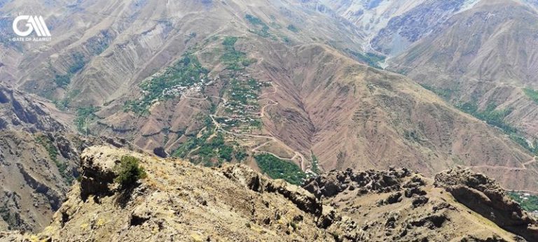
It was in the spring of 2022 that I received an email. The tourist was asking for a multi-day trekking trip in Alamut Valley including the visit to Alamut Castle, Lambesar Castle and the climb to Alam Kooh. The itinerary also included an exploration of Navizar Castle in Alamut Valley.

Up to that day, I have only heard the name of this castle and that was because of the hotel Navizar in Garmaroud. The hotel took its name from Navizar Castle in Alamut Valley.

Then I contacted Ali (my team member, living in Garmaroud) and asked about the castle and the possibility of this hiking.

I even tried to grasp some more information from the internet. Navizar Castle was not on google maps! The whole internet did not have really enough information about this castle.

But since my client had asked for it, I had to get prepared.

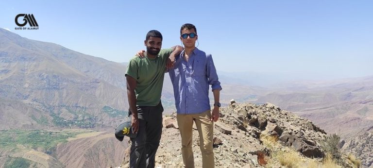
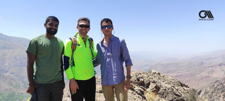
Ranvijay and Armaan, the two Indian tourists arrived in Iran for the tour with us.

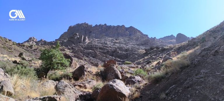
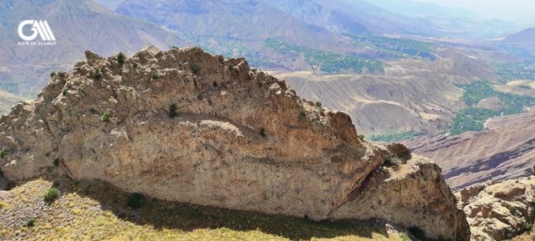
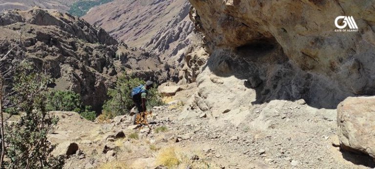
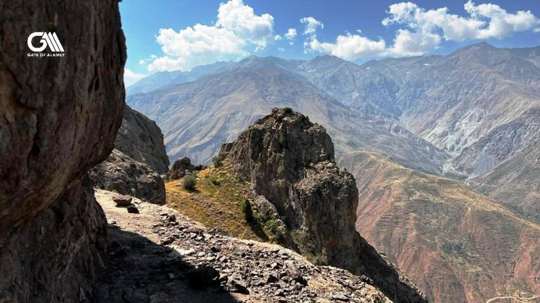
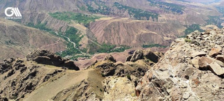
We explored the castle, we climbed to the most unknown castle of the Assassins in Persia. And I am sure it was the scariest climb, too.

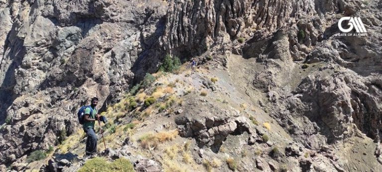
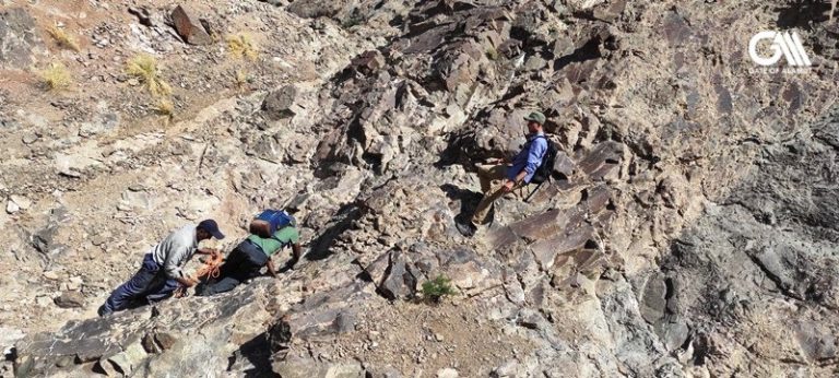
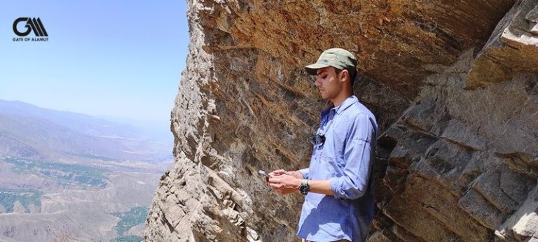
Ali was our local guide. He only had a mountaineering rope. On some occasions, he tied the rope to our waist, giving us the confidence to hike and pass.

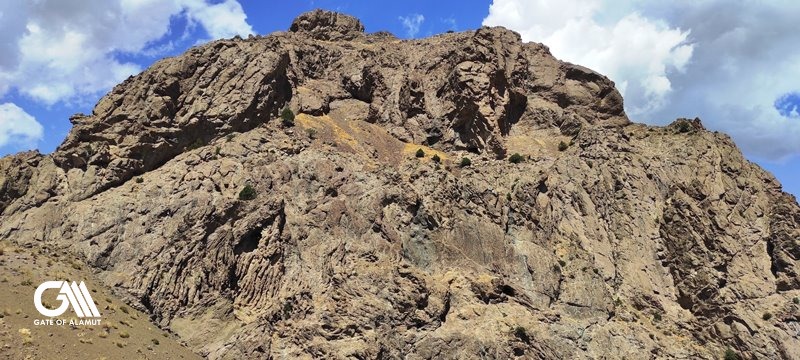
What I can say about Navizar Castle in Alamut Valley, is that you really need to be able to do some rock climbing. You absolutely need to be fit. The rock material in this trail prevents any kind of bolting in the stones. Ali’s rope is more of a mental help. You need to be careful where to put your feet and where to grasp to hike.

Not Many Tourists!

Ali told us during a ten-year period that he has been guiding tourists in the mountains, not more than five tourists were able to hike to Navizar Castle in Alamut Valley.

Even when I read books about Alamut Valley and the castles of the Assassins like Freya Stark’s or Dr. Peter Willey’s, not many Western travelers have noted their climb to this castle.

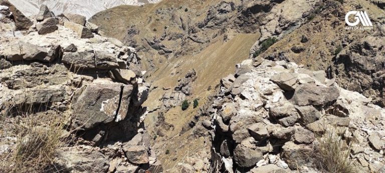
Navizar Castle is actually called Navizar Shah Castle. Shah means king. Seemingly the first lord of this castle was called Navizar.

The text material in this post is taken from the book: “Eagle’s Nest; Ismaili Castles in Iran and Syria” by “Dr. Peter Willey”.

Nevisar Shah

Nevisar Shah is situated almost at the eastern end of Alamut, near the village of Garmarud (there is another village of the same name at the western end of the valley).


Nevisar Shah occupies the most imposing site in the valley. Built at a height of just over 3,100 metres, the castle stands at the easterly tip of the valley of Alamut and commands a magnificent view over the mountains to the east and the whole valley to the west.

No finer view of the valley can be obtained. In the morning the scenery was particularly impressive, as the sun climbed over the Taleqan range to the south-east, gradually lighting up the whole of the Alamut valley below, and piercing the grey banks of mist and clouds that covered the entire area like some Wagnerian stage set.

To the east the valley is closed in by mountains which form a narrow defile and lead up to the Salambar Pass and the majestic Takht-e Suleyman, which has a height of 4,700 metres according to Freya Stark in her delightful account of her visit.

How to reach to Navizar Castle in Alamut Valley

The gruelling climb from the village of Garmarud to the castle of Nevisar Shah is an exhausting and dangerous climb of over 1,500 metres that took us six hours.

The risks entailed are considerable. There are no proper tracks, the steep slope and rocks are covered with loose pebbles and stones, and on all sides there are often sheer drops of several hundred metres.

The heat at midday is like an oven, and any water has to be fetched from a tiny spring 300 metres below.

The approach to the high citadel is through two ruined guardhouses at the western end. The general direction of the castle is NW/SE.

The high citadel stands about 25 metres above the second gateway and is approximately 50 metres long by 15 metres wide.

The building was largely destroyed by the Mongols, but the outline ground plan is clear enough. Below the citadel, the ground falls away in two sweeping arms separated by a steep scree slope that is just long enough to form the middle stroke of an ‘E’, which characterises the formation of the fortress as a whole.

The western arm is about 80 metres long and contains a complex water storage system. The cisterns are lined with plaster and in some cases roofed over. Jubes or channels connect each cistern. The average size of each cistern is 13 metres by 2.5 metres.

Topography of Navizar Castle

The eastern arm slopes down at an angle of about 30 degrees and is protected by a strong curtain-wall on the outside built over a sheer drop of 60 metres. A large number of two or three-storied houses are built into the eastern wall, and the area formed one of the principal living blocks of the castle for the officers and other important notabilities – civil, religious and military – of the garrison.

The best view of the principal, southern aspect of the castle can be obtained from the stable areas some 300 metres below.

The distance from the outer limit of the stable area to the top of the high citadel is approximately 580 metres. The stables have room for 60 to 80 horses and mules, and are connected to the main castle by a narrow causeway of earth that was once certainly fortified. The causeway drops steeply down to join a small narrow valley running in from the east, and

a track then winds up to the foot of the outer defences.

The distance from the outer limit of the stable area to the top of the high citadel is approximately 580 metres.

The impregnable nature of the site is emphasised by the deep gullies and ravines that surround the castle area. The view from the top is so magnificent that the sight and senses are almost overwhelmed.

Climbing up to Navizar Castle in Alamut Valley

All around are the very highest peaks of the Alborz mountains. Eagles soar and plunge hundreds of metres below. Breathing is painful and any movement seems to drain you of all energy.


No other fortress, in my opinion, brings home so forcibly the utter determination and sheer genius of Ismaili military architecture. The construction of a Crusader castle, even as splendid a building as Krak des Chevaliers, is child’s play compared to Nevisar Shah.

Even 500 years after its construction, my companions and I were lost in admiration of what remains of it. It is difficult to gauge the number of men who must have been employed in the back-breaking task of building the castle.

Certainly there were enough trees to provide the necessary scaffolding and woodwork, and stone was quarried from the nearby hills. Nevertheless, the number of men engaged in erecting the curtain-walls and the complex range of buildings must have been more than a thousand. It is also difficult to estimate the number of men who formed the garrison.

Probably this was no more than 500 or 600, but at the same time the castle could easily have accommodated another thousand or so, especially in times of siege.

Navizar Castle, a unique stronghold

Given the imposing and magnificent setting of Nevisar Shah, I can well understand why Ivanow considered that it must be the unidentified site of Maymundez. I found the Russian scholar’s name recorded, incidentally, in the visitors’ book of the headman at Garmarud. The headman told me that the professor had stayed with him while he investigated the castle area, but found the final ascent too steep to climb, and to his great chagrin was reduced to examining the castle as best as he could through binoculars.


But in any case, as I explained in my Castles of the Assassins, for all its impressive qualities, Nevisar Shah could not have been Maymundez. The citadel’s height and remoteness corresponded closely to Juwayni’s description of the site, but there was no place where the Mongol armies would have camped and there is no real circumference to the mountain (it is quite impossible to measure a circumference in terms of distance, let alone to determine the parsang Juwayni mentions explicitly).

There is no place where the Mongols could have erected their mangonels, nor is there any trace of the spring inside the castle itself. Juwayni says that the ramparts of Maymundez were built of plaster and gravel, but Nevisar Shah was constructed of dressed stone from the mountain of Boar Kuh, and cemented together with limestone cement of quite high quality.

Fall of Navizar Castle

Apart from the complete absence of space for an attacking force to set up its mangonels (the nearest flat plateau is 1,500 metres below the castle), the climate was the deciding factor in locating Nevisar Shah. We know that the siege of Maymundez took place at the end of November 1256.

 The Imam Rokn al-Din had hoped that he would be saved from the Mongols by the onset of winter, but the weather was unusually mild that year. There is no possibility of mild weather

at the top of the peak of Anarak-Dangaron on which Nevisar Shah is built.

Our headman told us that he had never known Anarak-Dangar to be without its mantle

of snow during November, and I have seen snow on the adjoining peaks even in summer.

Lastly, if we accept Juwayni’s account of Hulegu’s attack on Alamut, Nevisar Shah is too far to the east. Maymundez must be to the west of Alamut castle as Hulegu stopped at Sharak after he had captured Maymundez in order to rest and regroup before proceeding to Alamut.

Freya Stark in Navizar Castle

Nevisar Shah contains some very good examples of Ismaili pottery in all its considerable range. A guide appropriated one of the best examples of glasswork, a beautiful bottle with a fluted neck. It was clearly of local production and testified to the high degree of local craftsmanship. Freya Stark also found some pottery at Nevisar Shah when she made her way to Garmarud during her travels in Persia in 1931.

In Chapter 3 of her Valleys of the Assassins, she comments that she hunted among the stones of Nevisar Shah and found quite a large number of shards resembling the pottery she had found earlier at Alamut. She could not resist adding:

‘Thirteenth-century pottery in this deserted place, 3,000 feet above the nearest habitation.’ She concludes her observations with these words: ‘On every side the natural walls fall away in precipices; and from the highest point 10,000 feet at least, for my aneroid could rise no further, one can see the great half-circle of the eastern mountains, covered with snow, nameless on my map.

 It is a fascinating thought that Freya Stark and myself, with my team, are perhaps the only Westerners to have visited Nevisar Shah and recorded their impressions.

The Mongols and Navizar Castle

The main danger to the Ismaili defenders of Alamut of this part of Alamut valley came from armies approaching from the parallel Taleqan valley. This is, in fact, precisely what seems to have happened when the Mongols invaded Alamut in 1256.

They came up the Taleqan valley, crossed the mountain range to the east of Bidelan and seem to have aimed for the village of Shahrak, where the valley is at its widest. In this way they outflanked the other castles built by the Ismailis to defend an approach from the Taleqan.

 It seems probable that the Mongols must have moved at a very fast pace so that the garrisons of the Ismaili castles in Taleqan were either taken off guard or demoralised by the sheer size and rapid advance of the enemy.

There are two further Ismaili castles built with the express purpose of preventing penetration of the Alamut valley from the Taleqan. One is at Kay-Ghrobad, approximately 14.5 km south-west of Nevisar Shah that guards the north-south route along the eastern end of the Taleqan.

Its main features are the high citadel, the water cisterns which are situated both at the northern and southern ends of the castle, and the remaining stretch of wall at the southern end.

There was also a pottery kiln in the castle, which gives it an added importance. The other castle is called Mansuriyya, where we found particularly impressive water cisterns.

Taleqan Valley

The Taleqan, like the Alamut valley, is extremely fertile. The valley is broader than

Alamut, the villages richer, and considerably more crops are grown. During Ismaili

times the inhabitants of Kay-Ghrobad and Mansuriyya would certainly have used the food crops grown in the Taleqan to supplement their own resources.

Walls of Entrance Gate to Navizar
View of Alamut Valley from Navizar Castle
Difficult Ascend and Descend!
What a View!
The forgotten history!
Lovley Indians!
The multi-floor castle of Navizar!

Hiking to Navizar Castle in Alamut Valley

Many thanks to the Indian tourists (Armaan and Ranvijay) for booking this tour with us and sharing their photos.

This trek is apparently one of the toughest treks in Alamut Valley. It has a level of difficulty of 3.5 to 4.5. If this is over your fitness level, you can book other tours for trekking in Alamut Valley.

Are you ready to book an Alamut tour with me and explore the history of the Assassins in Iran? 

Just simply touch the whatsapp icon at the bottom of this page or go to contact us.

#alamut #alamout #alamot #ale_amut #ale_amoot #alamut_trip #alamut_tour #alamut_voyage #alamut_tours #alamut_castle #alamut_castles #alamut_history #alamut_fortress #alamut_valley #alamut_valley_tour #tour_to_alamut_valley #tour_to_alamut_castle #alamut_castle_tour #alamut_valley_guide #alamut_valley_local_guide #alamut_valley_history #assassins_history #assassins_history_iran #assassins_history_persia #castles_of_assassins #castles_of_assassins_iran #castles_of_assassins_persia #castles_of_assassins_history #history_of_assassins_iran #hashashin_persia #hashashin_order #hashashin_history #hashashin_assassins #best_alamut_guide #lambesar_castle_alamut #lamiasar_castle_alamut #lamisar_castle_alamut

1 thought on “Navizar Castle in Alamut Valley”

  1. Pingback: Armaan in Alamut Valley - Gate of Alamut

Comments are closed.